• Skip to primary navigation
  • Skip to main content
  • Skip to primary sidebar
  • Home
  • About
  • Contact
  • Join Us
  • Terms and Conditions
  • Privacy Policy
  • Blog

Nienadowa

Where Our Ancestors Lived / Gdzie Mieszkał Nasz Przodek

  • Biographies
  • Cemeteries
    • Albany Rural Cemetery
    • Cmentarz Komunalny, Dubiecko
    • Cmentarz Komunalny Głowny, Przemyśl
    • Cmentarz w Małkowicach
    • Cmentarz w Żurawicy
    • Notre Dame Cemetery
    • Our Lady of Angels Cemetery
    • Saint Agnes Cemetery
  • Census Records
  • Documents
  • Family Groups
  • Manor
    • The Manor House from a Diary
    • Photographs of The Manor in Nienadowa
  • Map Room
  • Nienadowa Family Tree
  • Photographs
    • Nienadowa – 1988
    • Nienadowa – 2021
    • Portraits
  • Vital Records
    • Nienadowa Birth Records
    • Nienadowa Marriage Records
  • Member Login
    • Password Reset
  • Opt-out preferences

Blog

Cadastral Maps of Nienadowa

November 5, 2020 By SJDankoSF Leave a Comment

Title - 1852 Nienadowa Cadastral Survey

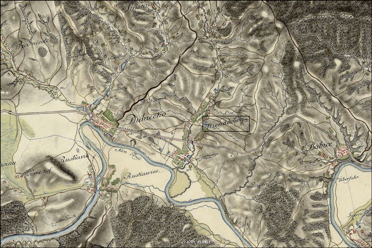
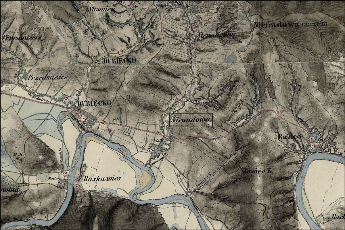
A survey of the Austrian Empire, including the Kingdom of Galicia and Lodomeria, was ordered by Emperor Francis I of Austria in 1817. This survey, known as the Franciscan Cadastre or the Stabile Cadastre, continued through 1861, and includes two known versions of the Cadastral Map of Niendowa, both of which have been uploaded to the Gesher Galicia Map Room.

The first revision of these are described as “feldskizzen” or “field sketches” in black and white, identifying individual parcels in Nienadowa by house number and the name of the landholder.

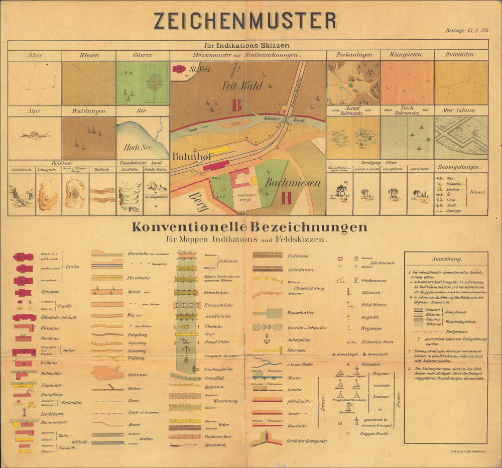
The second revision, this one in color, shows new buildings, changes in the courses of rivers and roads, but does not include the names of the landholders. In addition, the second revision replaces the house numbers with new property numbers, and uses color to identify building types and land use category (e.g. field, garden, meadow, forest, lake).

Legend: 1852 Nienadowa Map
Sebastian Fischer, Inspector, Dorf Nienadowa in Galizien Przemysler Kreis 1852 (Austrian Empire, 1852); digital images, Arachiwum Państwowe w Przemyśl (http://www.skany.przemysl.ap.gov.pl/show.php?zesp=126&cd=0&ser=0&syg=1127M : accessed 05 Oct 2020).

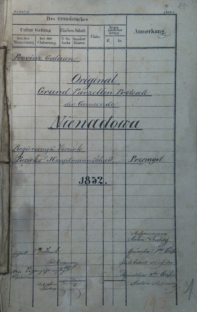
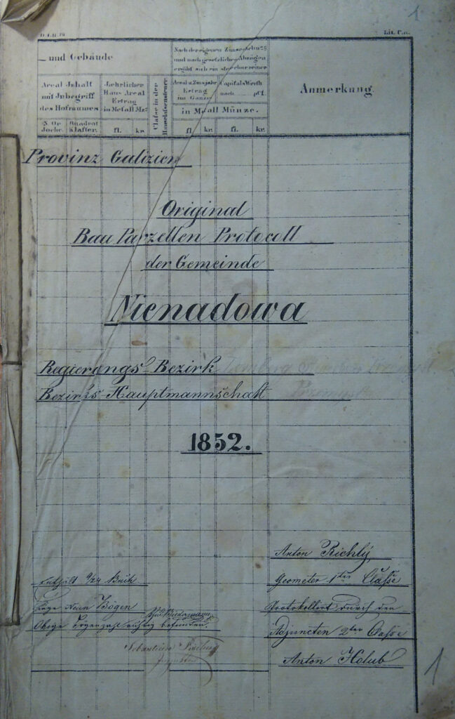
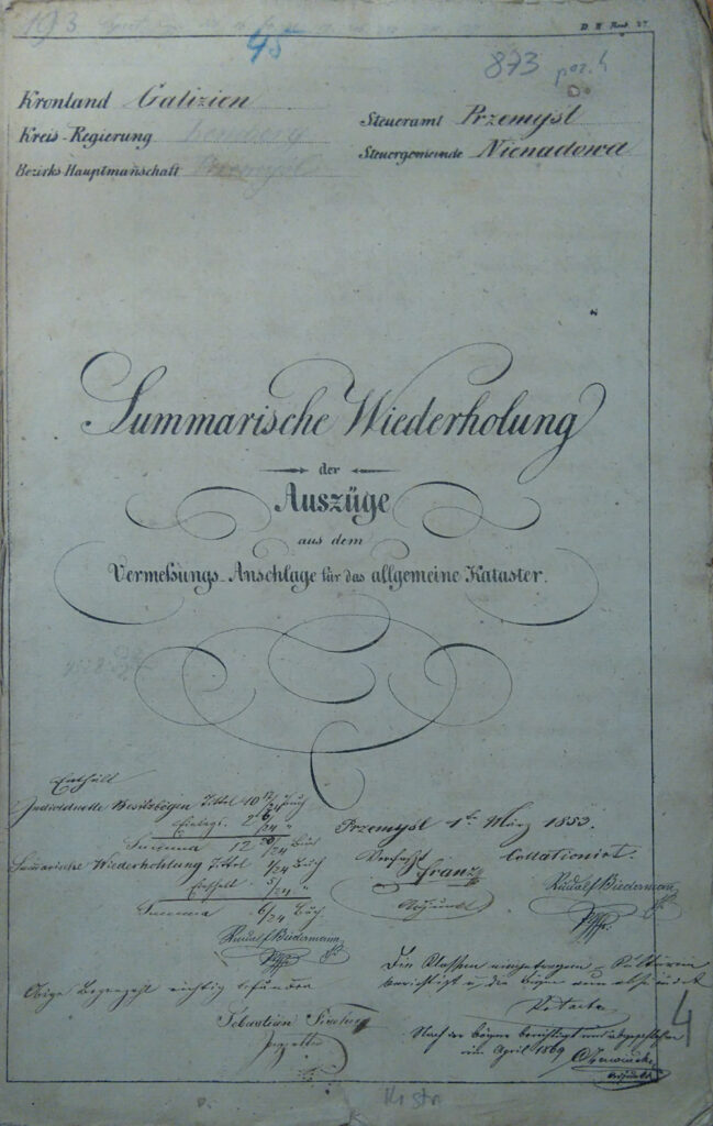
In addition to the maps, themselves, the cadastral surveys generated three written summaries, the Grundparzellen Protocoll (Field Plots Report), the Bauparzellen Protocoll (Buildings Report), and the Summarische Wiederholung (Summary and Recapitulation). Some of these written summaries are available in the Members Only area of this website. Otherwise, these documents are not yet available online.

Grundparzellen Protokoll - Nienadowa - 1852
Grundparzellen Protokoll – Nienadowa
Bauparzellen Protokoll - Nienadowa - 1852
Bauparzellen Protokoll – Nienadowa
Summarische Wiederholung - Nienadowa - 1852
Summarische Wiederholung – Nienadowa

Filed Under: Uncategorized

Nienadowa in the Austrian Military Surveys

October 18, 2020 By SJDankoSF Leave a Comment

Galicia Thumbnail Map

Nienadowa is represented in the three Austrian Military Surveys: the first in 1779–1783, the second in 1861–1864, and the third in 1869-1887.

Nienadowa in the First Military Mapping Survey (1779-1783)
SOURCE: First Military Mapping Survey (1779-1783). Online https://mapire.eu/en/map/firstsurvey-galicia/?; downloaded 17 Oct 2020.
Nienadowa in the Second Military Mapping Survey (1779-1783)
SOURCE: Second Military Mapping Survey (1779-1783). Online https://mapire.eu/en/map/secondsurvey-galicia/?; downloaded 17 Oct 2020.
Nienadowa in the Third Military Mapping Survey (1869-1887)
SOURCE: Third Military Mapping Survey (1869-1887). Online https://mapire.eu/en/map/thirdsurvey25000/?; downloaded 17 Oct 2020.

Copyright © 2020 by Stephen J. Danko

Filed Under: Uncategorized

The Polish Village of Nienadowa

October 14, 2020 By SJDankoSF Leave a Comment

Słownik Geograficzny

The Geographical Dictionary of the Kingdom of Poland and other Slavic Countries (Słownik geograficzny Królestwa Polskiego i innych krajów słowiańskich) is a multi-volume gazetteer published in 1880-1892 in Warsaw. Each entry provides information about places in Poland and nearby countries as the place was at the time of publication.

Chlebowski, Bronisław, Władysław Walewski, and Filip Sulimierski, eds., Słownik Geograficzny Królestwa Polskiego i Innych Krajów Słowiańskich (Geographical Dictionary of the Kingdom of Poland and other Slavonic Countries) – Warsaw 1886, Volume VII, page 101.

Nienadowa, szczyt górski pod wsią, t. n., pow przemyski, ob. Nienadowa wieś.
Nienadowa, rus. Nenadowa, wś, pow. przemyski, 28 klm. na płn.-zach. od sądu pow. w Przemyślu, 3 klm. na wsch. od urzędu posz. w Dubiecku. Na wsch. leżą Babice, Skopów, Kramarzówka (w pow. Jarosławskim), na płn.-zach. Hucisko Nienadowskie, na zach. Śliwnica, Dubiecko i Ruska i wież (w pow. Brzozowskim), na płd. Iskań (w pow. Dobromilskim). Wzdłuż granicy płd.-zach. i płd. płynie San, zrazu od płn.-zach. na płd.-wsch., poczem skręca na płn.- a nakoniec na wsch. Od lew. brz. wpadają do Sanu w obrębie wsi: pot. Kamieniec, płynący od płn. z Huciska Nienadowskiego, zabierający liczne strugi z obu brzegówi pot. Świnka, płynący od płn. na płd.-zach. Zabudowania wiejskie leżą w dolinie Kamieńica (306 m. na płn., 284 m. na płd.). Część płn. obszaru zajmuje las „Jodłowski dział” (378 m.), a narożnik płd.-wsch. las „Słoniec”. Między dolnym biegiem Kamieńca a Świnki wznosi się na lew. brz. Sanu „Góra od Świniek”; w stronie zach. na granicy Dubiecka „Góra Gabińska” (361 m.), a w stronie płn.-wsch. na granicy Kramarzówki „Nienadowa” (do 443 m.; znak triang.). Przez płd. część wsi idzie gościniec wiodący z Przemyśla malowniczą doliną Sanu przez Dubiecko do Dynowa. Własn. więk. ma roli or. 675, łąk i ogr. 72, pastw. 49, lasu 818; wł. m. roli or. 1452, łąk i ogr. 153, p. 312, lasu 184 mr. W r. 1880 było 1823 mk. w gminie, 109 na obsz. dwor. (między niemi 1625 o brz. rzym.-kat.). Par. rzym. i gr. kat. w Dubiecku. We wsi jest szk. etat. jednokl., dwór, folwark, gorzelnia, młyn i leśniczówka. O dawnych właścicielach wsi podaje kilka szczegółów Siarczyński (Rkp. Ossol., No 1826). W r. 1588 odstąpił ją Stanisław Stadnicki w zamian za Łańcut Annie z Sienna Pileckiej, po niej prawem następstwa przeszła ona do Sienińskich; potem dzierżyli ją Dersznakowie, Krasiccy, Dembińscy. Lu. Dz.

Nienadowa, a mountain peak near a village of the same name in the Praemyśł Powiat, see Nienadowa village.
Nienadowa, Nenadowa in Ruthenian; a village in Przemyśł Powiat, 28 kilometers to the north-west of the powiat court in Przemyśl, 3 kilometers east of the post office in Dubiecko. To the east are located Babice, Skopów, Kramarzówka (in Jarosław Powiat), to the north-west Hucisko Nienadowskie, to the west Śliwnica, Dubiecko and Ruska wieś (in Brzozów Powiat), to the south Iskań (in Dobromil Powiat). The San River flows along the south-west and southern border, initially from the north-west to the south-east, then it turns to the north-west and to the east. From the left bank, the following streams flow from within the village into the San River: the Kamieniec Stream, flowing from the north from Hucisko Nienadowski, absorbing numerous streams from both banks, and the Świnka Stream, flowing from the north to the south-west. The village buildings are situated in the Kamieńica valley (306 m to the north, 284 m to the south). The northern part of the area is occupied by the “Jodłowski section” forest (378 m), and the south-east corner by the “Słoniec” forest. Between the lower reaches of Kamieniec and Świnka, the “Góra od Świniek” rises on the left bank of the San; on the west side, on the border of Dubiecko, “Góra Gabińska” (361 m), and on the north-east side, on the border of Kramarzówka, “Nienadowa” (443 m, triangulation mark). The road leading from Przemyśl through the picturesque San valley through Dubiecko to Dynów goes through the southern part of the village. The larger property has 675 mórgs [1 mórg = 5755 m²] of arable land, 72 mórgs of meadows and gardens, 49 mórgs of pastures, 818 mórgs of forests; the property has 1452 mórgs of arable land, 153 mórgs of meadows and gardens, 312 mórgs of pastures, and 184 mórgs of forests.In 1880, there were 1,823 m2 residents in the gmina, 109 residents on the area of the manor (between them there were 1625 residents on the Roman Catholic shore of the San River). There are Roman Catholic and Greek Catholic parishes in Dubiecko. In the village there is a full-time one-room school, a manor house, a farm, a distillery, a mill, and a forester’s lodge. Siarczyński gives some details about the former owners of the village (Rkp. Ossolineum, No. 1826). In 1588, Stanisław Stadnicki gave up Nienadowa to Anna of Sienna Pilecka in exchange for Łańcut, after which Nienadowa passed to the Sieniński family by succession; then it was held by the Dersiniaks, the Krasickis and the Dembińskis. Lukasz Dz.

Copyright © 2020 by Stephen J. Danko

Filed Under: Uncategorized

Primary Sidebar

Member Login

Forgot Password?
Join Us

Recent Posts

  • Cadastral Maps of Nienadowa
  • Nienadowa in the Austrian Military Surveys
  • The Polish Village of Nienadowa

Archives

  • November 2020
  • October 2020
May 2025
M T W T F S S
 1234
567891011
12131415161718
19202122232425
262728293031  
« Nov    

Copyright © 2025 · Nienadowa· All Rights Reserved

Manage Consent
To provide the best experiences, we use technologies like cookies to store and/or access device information. Consenting to these technologies will allow us to process data such as browsing behavior or unique IDs on this site. Not consenting or withdrawing consent, may adversely affect certain features and functions.
Functional Always active
The technical storage or access is strictly necessary for the legitimate purpose of enabling the use of a specific service explicitly requested by the subscriber or user, or for the sole purpose of carrying out the transmission of a communication over an electronic communications network.
Preferences
The technical storage or access is necessary for the legitimate purpose of storing preferences that are not requested by the subscriber or user.
Statistics
The technical storage or access that is used exclusively for statistical purposes. The technical storage or access that is used exclusively for anonymous statistical purposes. Without a subpoena, voluntary compliance on the part of your Internet Service Provider, or additional records from a third party, information stored or retrieved for this purpose alone cannot usually be used to identify you.
Marketing
The technical storage or access is required to create user profiles to send advertising, or to track the user on a website or across several websites for similar marketing purposes.
Manage options Manage services Manage {vendor_count} vendors Read more about these purposes
View preferences
{title} {title} {title}